Substation and data centre siting software
A site is only as good as the connections it needs. Optioneer optimises both at once.
Most siting tools rank parcels. They tell you which land is available, flat and correctly zoned — and leave the cost of getting power, water and gas to it as a problem for later. That is where site selections go wrong, and where months of development budget disappear.
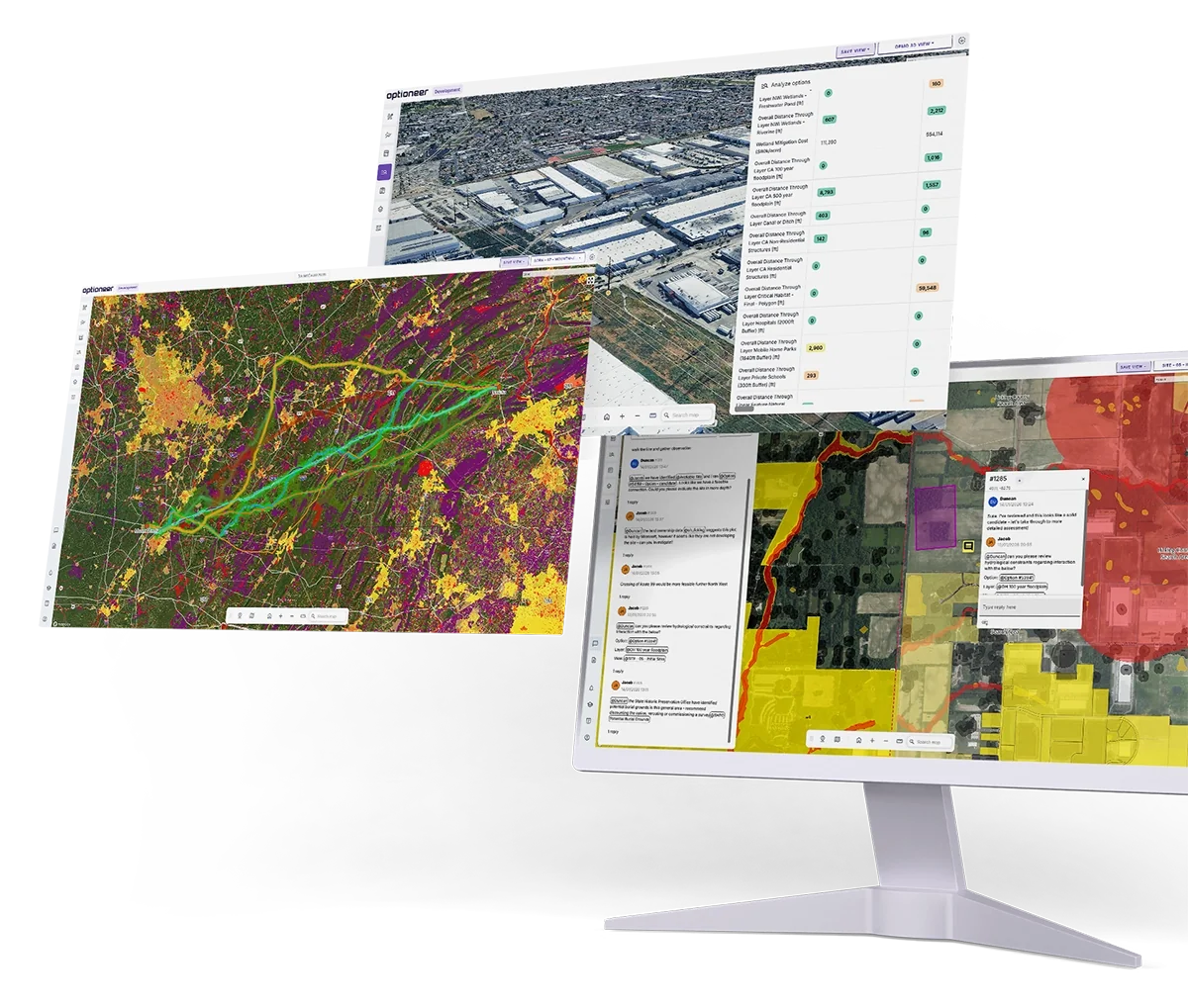
Optioneer evaluates candidate sites and the routes serving them in a comprehensive optimisation flow, across electricity, gas and water networks simultaneously. Land availability, access, ownership and zoning are constraints in that search, not a separate screening step. The result is a ranked, costed, defensible shortlist — produced in hours, with the evidence trail attached.
for siting and routing studies of any site
and 5 substation locations assessed, with a preferred option selected within 8 weeks
of US land parcel coverage through Regrid, the authoritative national parcel dataset
GW sitting in US interconnection queues — siting speed is now the constraint
What is substation and data centre siting software?
Substation and data centre siting software is a geospatial optimisation tool that identifies and ranks candidate locations for a facility by evaluating the land itself alongside the infrastructure connections it will require.
It converts land ownership, zoning, terrain, environmental, network and cost data into a spatial model, then searches for the locations that minimise total delivered cost and risk rather than land cost alone.
It differs from parcel screening tools in four ways:
It optimises the site and its connections together.
A cheap parcel six kilometres from the nearest viable substation is not a cheap site. The connection routes are part of the objective function, not a downstream consequence.
It handles multiple utilities at once.
Electricity, gas and water — because a modern load is not sited against one network, it is sited against three.
It tests buildability, not just availability.
Usable area after setbacks, earthworks, flood risk and ground conditions decide whether a well-zoned parcel is a real option.
It produces an audit trail.
Every option carries the constraints, weights and parameters that produced it — which is what survives a planning committee, a zoning hearing or an internal investment review.
Optioneer does all four, for substations, converter stations, data centres, BESS and other large-load or network sites.
Teams supported
Every team member — internal and external — works in the same project environment, from prospecting to consent.

Development & Origination

Engineering & Grid Connection

Environment & Permitting

Consent & Stakeholders

Utilities & Site Services

Storage, Flexibility & Co-location
The data your siting study runs on
Siting quality is bounded by data quality. Optioneer ships with an integrated catalogue of infrastructure, environmental, regulatory, geological and land ownership datasets covering the US, UK and EU, structured into thematic layers that are ready to weight and run — so teams reach a usable shortlist in hours rather than after weeks of GIS assembly.
You can upload your own layers alongside the catalogue, and the platform interoperates with ArcGIS and Autodesk Construction Cloud.
Authoritative US land ownership and zoning
Regrid
In the US, Optioneer is built on Regrid parcel data — the authoritative national land parcel dataset, with coverage across all 50 states. Every candidate site is assessed against real parcel geometry and real ownership rather than an approximate boundary, which changes what a siting study can conclude.
That means Optioneer can answer, at screening stage:
- Who owns it — owner names and mailing addresses, so an outreach list falls out of the shortlist rather than following weeks later
- How fragmented is it — how many parcels and how many separate owners a site assembly would involve, which is usually the single best predictor of how long acquisition will take
- What is permitted — standardised zoning classifications and land use codes, including zoning type and subtype, permitted uses and development controls such as setbacks and floor area ratio
- How big is it really — parcel acreage and geometry, so usable area after setbacks and exclusions can be calculated rather than estimated
- What is already on it — building footprints and current land use, distinguishing genuinely vacant land from occupied or partially developed sites
Because parcels are the same objects the routing engine uses, the connection routes are optimised to cross as few parcels and as few separate owners as possible — the land strategy for the site and the land strategy for its connections are produced together.
UK and EU equivalent: HM Land Registry National Polygon Service, giving visibility of Crown land and commercially owned property, and INSPIRE-harmonised parcel data across EU member states.
Model the facility you are actually building
Optioneer's asset library holds a parametric definition of your sites and the linear assets connecting them, so the optimiser is bound by the same rules as your engineers.
Definitions are reusable across projects, keeping assumptions consistent across a whole development pipeline.
How Optioneer finds high-quality sites
Optioneer combines least-cost path analysis with evolutionary, multi-objective optimisation.
For siting, the important property is that the same engine evaluates the site and its connections, so they can be optimised against each other rather than in sequence.
Build the cost model
Every constraint layer is assigned a behaviour: hard exclusion, or a cost applied per unit area occupied, per unit length traversed, or per unit of proximity. Costs can be monetary or expressed as risk and impact weights against your own governance methodology. The result is a continuous multi-layer cost model spanning the whole search area — used both to score candidate sites and to price the routes reaching them.
Generate candidate sites
Candidate locations are identified from the cost model and from parcel geometry: areas large enough, flat enough, correctly zoned and free of hard exclusions, with usable area calculated after setbacks rather than taken as gross parcel area.
Sites you are already considering — options held, brownfield holdings, parcels an agent has surfaced — are added to the same pool and assessed on identical criteria.
Least-cost connection paths
For each candidate site, graph search across the cost model returns minimum-cost connections to the relevant network access points — electricity, gas, water, wastewater. This produces a defensible connection cost per site in place of a straight-line distance estimate, which is where most conventional site screening quietly goes wrong.
A least-cost path is not yet a buildable route: it has no concept of deviation angle, span, bend radius or cover depth. It is the right tool for the comparison at this stage, and Step 4 turns the survivors into real alignments.
Evolutionary refinement of site and route together
Optioneer then treats siting as a search over combined configurations: a site position and footprint together with the alignments serving it. A population of candidates is generated and, each generation, recombined and mutated — the site shifts within or between parcels, the footprint rotates or reshapes, connection routes re-optimise against the moved site, a route switches from overhead to underground, a connection re-targets a different substation or main.
Every candidate is scored by full evaluation applying the engineering rules from your asset library, so configurations that cannot achieve the platform gradient, breach a setback, exceed a deviation limit or demand an unbuildable approach are penalised or discarded.
Because the site and the routes move together, the search finds configurations that sequential analysis structurally cannot: a site 400 metres from the obvious parcel that halves the connection cost, or a footprint rotation that changes which line entry approach is feasible.
Evaluate, compare, iterate
Every option is scored against the same metric set: usable area, earthworks volume, connection lengths and costs by utility, parcels and owners affected, crossings, distance to receptors, environmental metrics, CAPEX and OPEX supporting AACE Class 4 estimates (Class 3 with engineer review), and custom metrics built around your own governance.
Weighted ranking, red-amber-green fatal-flaw screening and Pareto analysis all run over the same set. Change a parameter — a larger platform, a different voltage, a phase-two expansion allowance — and re-run in minutes.
Optimisation executes in the cloud with no local compute requirement, which is what allows portfolio-scale screening across an entire ISO/RTO footprint or service region.
The central point of this page, and the thing most siting tools do not do
Simultaneous siting and routing
Conventional practice sites first and routes second: shortlist parcels on land criteria, then hand the winner to engineering to work out how to connect it. By the time the connection cost is known, the site is effectively fixed, and any bad news becomes a cost overrun rather than a different decision.
Optioneer inverts that. Connection cost is part of the siting objective from the first run, so the ranking you get is a ranking of delivered cost. A parcel that is cheap, flat and correctly zoned but sits behind a river, a railway and a designated site will rank where it deserves to.
Optimal positioning against electricity, gas and water networks at once
A substation is sited against the electricity network. A data centre is sited against three networks simultaneously — power in, water in and out, and often gas for on-site generation — and the optimal location for one is rarely the optimal location for the others.
Optioneer models all of them in the same run. Each connection is routed and costed against real constraints, and the trade-off between them is explicit: how much additional power connection cost is justified by a shorter water main, whether a site near a trunk sewer is worth a longer grid tie-in. Because every utility uses the same constraint baseline and cost framework, the comparison is like-for-like rather than assembled from three separate studies with three sets of assumptions.
Land availability, assembly and access
Availability is not the same as viability. Optioneer assesses:
- Usable area after setbacks, exclusions, easements and unbuildable ground — not gross parcel area
- Assembly complexity — how many parcels and how many distinct owners a site requires, and whether a single holdout would break it
- Shape and orientation — whether the required footprint actually fits, and at what rotation
- Construction access — highway access, weight and headroom limits along the delivery route, and feasibility for abnormal indivisible loads such as transformers
- Operational access and the cost of any new access road the site would require
- Encumbrances — existing easements, rights of way and third-party infrastructure crossing the parcel
Brownfield and existing site reuse
Brownfield sites are frequently the fastest route to a connection — retiring generation sites, former industrial land and existing substation sites come with grid infrastructure, established access and, often, a more permissive planning history. They also come with remediation liability, constrained footprints and ground risk.
Optioneer assesses brownfield and existing-site options on the same constraint baseline, scoring methodology and cost framework as greenfield alternatives, so the comparison is direct and auditable. That includes:
- Extending or reconfiguring an existing substation site versus building new, including whether the existing footprint can absorb additional bays and line entries
- Reusing retired or retiring generation sites where an existing connection and its capacity may transfer
- Contaminated and previously developed land, with remediation and ground risk carried as cost rather than discovered later
- Post-development encroachment — whether constraints that appeared since the original site was developed now compromise expansion
Substation siting in detail
Platform area and configuration drive land take; line entry directions and approach angles determine whether a footprint works at all on a given parcel. Optioneer assesses candidate positions against terrain for earthworks volume, checks approach corridors for each incoming and outgoing circuit, and scores noise and visual impact against nearby receptors. Where a site forms part of a wider scheme, the substation position and the connecting line routes are optimised together rather than fixed in sequence.
Data centre siting in detail
Power availability is usually the binding constraint, and it is spatial: proximity to substations with genuine headroom, transmission capacity in the area, and the practicality of a dual feed. Optioneer scores candidate sites against the network, routes both feeds, and prices them.
Water follows — supply for the cooling approach adopted and a discharge route for effluent, both routed and costed rather than assumed available. Gas is included where on-site generation or fuel cells are in scope. Fibre routes and latency requirements can be uploaded as project layers and weighted alongside everything else.
Land, zoning and community factors then determine whether the site can be consented: permitted use and development controls from parcel-level zoning data, setback and height compliance, noise to nearby receptors, and the visual and traffic profile that will shape local opposition.
Where siting teams use Optioneer
Network and system planning
Project development and consenting
What changes when siting is optimised
Frequently asked questions
How is this different from a parcel screening or site selection tool?
Parcel tools rank land on land attributes. Optioneer ranks sites on delivered cost — the land plus the routed, costed connections it needs across electricity, gas and water. The site and its connections are optimised in the same search, so a well-priced parcel with expensive connections ranks accordingly rather than winning the shortlist and disappointing later.
Can it site a data centre and route its power, water and gas connections in one study?
Yes. That is the core workflow. Each utility is routed against the same constraint baseline and cost framework, so the trade-offs between them are explicit rather than assembled from separate studies.
What land ownership data do you use in the US?
Regrid, the authoritative national parcel dataset, with coverage across all 50 states — parcel boundaries and geometry, ownership records, addresses, building footprints, and standardised land use and zoning classifications. In the UK, HM Land Registry National Polygon Service; across the EU, INSPIRE-harmonised parcel data.
Does it check zoning?
Yes, using standardised zoning classifications matched to parcels — zoning type and subtype, permitted uses and development controls such as setbacks and floor area ratio. Zoning is set locally and standardised coverage is strongest in populated jurisdictions, so we treat it as a screening input rather than a substitute for a planning opinion.
Can it assess brownfield and existing sites?
Yes, on the same constraint baseline, scoring methodology and cost framework as greenfield alternatives, so the comparison is direct. That covers extending an existing substation, reusing a retired generation site, and previously developed or contaminated land with remediation carried as cost.
Does it check construction access?
Access is assessed against the road network, including feasibility for abnormal indivisible loads such as transformers, and the cost of any new access road a site would require.
How accurate are the cost estimates?
CAPEX and OPEX outputs support AACE Class 4 estimates automatically, and Class 3 with engineer review. Estimates build from the option itself — usable area, earthworks volume, connection lengths by asset type and terrain, crossings, land take — using your cost book or an established framework.
Can outputs be used in a permit or planning application?
Yes. Customers use Optioneer outputs in DCO and TCPA applications in the UK, and in NEPA, state siting and local zoning processes in the US. The platform produces the constraint maps, options appraisal evidence, impact tables and audit trail those processes require. Expert interpretation and authorship remain with your team.
How long does a siting study take?
Siting and routing studies for a site typically run in under two hours. Portfolio-scale screening across a region is same-day. A full multi-site appraisal with stakeholder-ready materials is a matter of weeks rather than months.
Does it replace engineering and planning judgement?
No. It removes the data assembly and iteration work that consumes most of a siting study, and widens the field your experts get to judge. The decisions stay with the people accountable for them, with better evidence behind them.
Test it against a site you already know
Bring a live search, a parcel under option, or a site you have already selected — the fastest way to judge the platform is to run it against a decision where you know the answer.
Client success stories
We’ve had the pleasure of working with global leaders in the utilities industry, find out how they achieved results with Optioneer.





















Learn how Optioneer can accelerate your project development programmes

We will be in touch with you shortly.