Electric transmission routing software
Route overhead lines, underground cable and HVDC against real-world constraints — not assumptions.
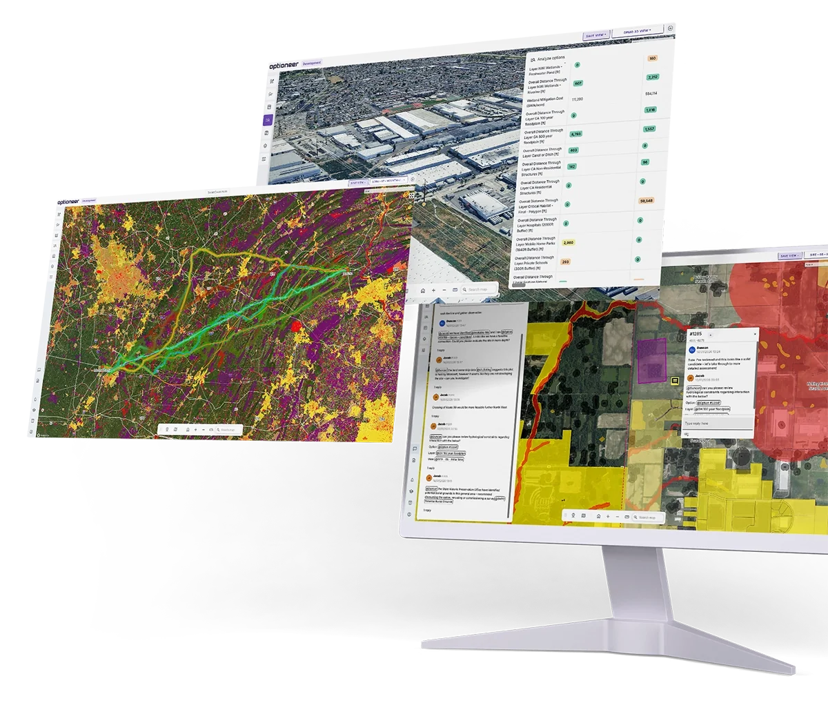
Optioneer is a cloud routing and siting platform for transmission. It combines a pre-loaded constraint database, a parametric model of your structures and conductors, and multi-objective optimisation to generate buildable route options across whole regions — each one costed, quantified, and traceable back to the data and weights that produced it.
Built for transmission owners, system operators, competitive developers and their consultants across the US, UK and EU.
kilometres of transmission evaluated inside a single competitive window, by a single customer
reduction in routing time, measured in an Energy Networks Association study
of linear assets designed in Optioneer
of network planning brought forward for a British transmission utility
What is electric transmission routing software?
Electric transmission routing software is a geospatial optimisation tool that identifies, evaluates and compares candidate routes for a transmission line between defined endpoints.
It works by converting environmental, land, engineering and cost data into a spatial cost model, then searching that model for alignments that minimise total impact and cost while remaining physically buildable.
Modern routing platforms differ from traditional GIS analysis in four ways:
They generate options, rather than evaluate a route you have already drawn.
The engineer sets the objectives; the software searches the solution space.
They optimise across several competing objectives at once.
Capital cost, environmental impact, visual impact, land take and deliverability are each tracked in their own right, instead of collapsing everything into one weighted score.
They model the asset, not just the line.
Structure type, span, deviation angle, right-of-way width and clearance constrain which geometries are actually achievable.
They produce an audit trail.
Every option carries the constraint set, weights and parameters that created it, so a route selection can be defended years later. The metrics are more detailed than in traditional GIS and include engineering- and permit-driven requirements.
Optioneer does all four, for overhead line (OHL), underground cable (UGC) and HVDC schemes. Optioneer also takes into account existing assets and right-of-way, evaluating potential upgrades and colocation opportunities.
The data your routing study runs on
Route quality is bounded by data quality. Optioneer ships with an integrated catalogue of infrastructure, environmental, regulatory and land ownership datasets covering the US, UK and EU, structured into thematic layers that are ready to configure and run — so teams start optimising in hours instead of spending weeks assembling a baseline.
You can upload your own layers alongside the catalogue. Optioneer supports standard geospatial formats and interoperates with ArcGIS and Autodesk Construction Cloud.
Constraint layers are grouped against the legislation and permits they relate to, so an environmental planner sees the same route through the lens of the consent they have to secure.
Model the line you would actually build
Routing is only credible if the option is buildable. Optioneer's asset library holds a parametric definition of your transmission assets, so the optimiser is constrained by the same rules as your design engineers.
Definitions are reusable across projects and teams, which keeps engineering assumptions consistent across a whole capital programme.
How Optioneer finds high-quality routes
Optioneer combines least-cost path analysis with evolutionary, multi-objective optimisation.
The two techniques answer different questions, and the combination is what produces alignments that are both near-optimal and buildable.
Build the cost model
Every constraint layer is assigned a behaviour: hard exclusion, or a cost applied per unit length traversed, per feature crossed, or per unit of proximity. Costs can be monetary, or expressed as risk and impact weights against your own governance methodology. The result is a continuous multi-layer cost model across the whole study area, resolving to the granularity your data supports. This is a commonly used approach for a 'cost surface' and follows best practice laid out by institutions like EPRI.
This step is where organisational knowledge is encoded once and reused. Weighting frameworks can be saved and applied across an entire programme so that every scheme is assessed on the same basis.
Least-cost path and corridor identification
A graph search across the cost model returns the minimum-cost connection between endpoints, together with cost-distance surfaces that show where viable corridors exist and how much cheaper the best corridor is than its alternatives.
This is fast and mathematically clean — for a given cost model, the least-cost path is provably the cheapest traversal. It is the right tool for screening: identifying which of a hundred candidate connection points are worth pursuing, and where the strategic corridors lie.
But a least-cost path alone is not a transmission route. It has no concept of deviation angle, span length, structure spotting or minimum straight sections, so it can return a geometry no one can build. And it produces one answer per weighting, which tells you nothing about the trade-offs you are making.
Evolutionary refinement into buildable alignments
Optioneer therefore treats routing as a search over buildable options, not over grid cells.
A candidate route is represented by its defining vertices — the angle points that a real line would use. A population of candidates is generated, seeded from least-cost corridors, existing rights-of-way, and any options your team has drawn manually. Each generation, candidates are recombined and mutated: vertices move, are inserted or removed, sections switch asset type from overhead to underground, spans and structure selections are re-derived along the terrain profile.
Every candidate is then scored by a full evaluation — not a proxy. That evaluation applies the engineering rules from your asset library, so alignments that violate a deviation limit, exceed a maximum span, cross an unbuildable slope or breach a clearance are penalised or discarded. Candidates that survive are, by construction, geometries you could take forward.
Over successive generations the population converges on high-performing alignments. Because the search is stochastic and population-based, it explores parts of the solution space a single deterministic path will not reach — including alignments that are slightly longer but materially cheaper to build, or that avoid a receptor group entirely.
Multi-objective search and the trade-off frontier
Objectives are kept separate rather than collapsed into a single number. CAPEX, environmental impact, visual impact, land and landowner exposure, and deliverability are each tracked in their own right.
The optimiser therefore returns a set of diverse options — where no option can improve on one objective without giving ground on another, or to ensure that spatially diverse options are taken forward. That set is the honest answer to a routing question, and it is what your governance process actually needs: not “the route”, but the shape of the choice between a cheaper alignment and a less visible one.
Objective visualisation, weighted multi-criteria ranking and red-amber-green screening are all available over the same option set, so a strategy team, an environmental lead and a cost engineer can each interrogate the same results on their own terms.
Evaluate, compare, iterate
Every option — optimiser-generated or hand-drawn — is scored against the same metric set. Hundreds of metrics are calculated automatically: length through each constraint layer, count of features within a given distance, structure counts, crossing schedules, quantity take-offs, CAPEX and OPEX supporting AACE Class 4 estimates (Class 3 with engineer review), and custom metrics built around your own permits and governance.
Engineers can then move a structure, nudge a vertex, change a parameter and re-run. Iteration takes minutes, so the cost of asking “what if we moved it east of the ridge?” drops close to zero.
The optimisation executes in the cloud, in parallel, with no local compute requirement. That is what allows customers to evaluate entire ISO/RTO footprints — PJM, MISO, CAISO and SPP among them — or country-scale corridor studies, rather than one project at a time.
Built around how transmission lines are actually routed
Generic corridor tools stop at a line on a map. Transmission routing decisions are made on structures, spans, sightlines and rights-of-way — so that is what Optioneer models.
Visual impact and structure visibility
Visibility is usually the objection that decides a scheme, and it is a function of where individual structures sit, not where the centreline runs. Optioneer assesses candidate structure positions against viewpoints, settlement edges, recreational areas and landscape designations, and lets you trade visibility against cost explicitly. Options can be rendered in photorealistic 3D terrain with parametric structures and conductors, and exported as flyovers and print-ready maps for consultation.
Structure selection and spotting
Structure family is a routing variable, not a downstream detail. Terrain, constraint density and consent context can each argue for a different family, and the choice propagates directly into cost, land take and visual profile. Optioneer returns key structure locations along each alignment — including angle structures at each deviation — so counts, schedules and costs reflect a real line.
Spans, terrain profile and clearance
Span selection is derived along the terrain profile within the minimum and maximum spans defined for the structure family, respecting ground clearance and crossing clearance. Long spans at valley and watercourse crossings, and constrained spans through undulating terrain, are reflected in structure counts before the option is shortlisted rather than after.
Right-of-way width and land take
RoW width follows from voltage, structure geometry and clearance requirements, and it drives most of the downstream consequences: easement area, number of affected landowners, forestry and habitat clearance, biodiversity liability, and construction footprint. Optioneer treats corridor width as a parameter of the asset, so widening a RoW to accommodate an additional circuit shows up immediately in land, environmental and cost metrics.
Colocation and paralleling existing rights-of-way
Following an existing corridor is often the fastest route to consent — and sometimes the most expensive way to build. Optioneer evaluates paralleling and RoW-following against greenfield alternatives concurrently, not as a separate exercise, so the comparison is like-for-like. That includes:
- Voltage uprating and reconductoring of an existing line as an alternative to new-build
- Widening an existing RoW or adding circuits, with the incremental land and consent implications quantified
- Paralleling transmission, highway, rail and pipeline corridors at a defined offset
- Post-construction encroachment — checking whether constraints that have appeared since the original line was built now compromise the corridor
OHL / UGC / HVDC hybrid design
Sections can switch asset type automatically where topography, designation or policy makes overhead line untenable, with transition compounds, cable-specific constraints and the full cost differential applied. Undergrounding is then a modelled option with a price attached, rather than a concession made under consultation pressure.
Crossings, access and constructability
Crossings of existing circuits, rail, highways, watercourses and other utilities are identified and scheduled. Access track requirements, slope limits and terrain suitability are applied during option generation, so comparisons reflect what can be built and reached — on every option, not only the preferred one.
Where transmission teams use Optioneer
System planning and network development
Optioneer complements system planning tools such as PSS®E, PLEXOS, PROMOD and PlanOS — they tell you what the network needs; Optioneer tells you whether and where it can physically go.
ISO/RTO regional planning cycles and FERC Order 1000 competitive solicitations — PJM RTEP reliability and market efficiency windows, MISO MTEP and LRTP, SPP ITP, CAISO TPP phases 2 and 3, ISO-NE RSP/LTTP, NYISO CSPP. Also interconnection cluster study support and load-growth-driven reinforcement, including large-load and data centre connections.
RIIO-ET3 business plan and regulatory submissions, ASTI programmatic delivery across the 26 priority projects, evidence for NESO Connections Reform “first ready and needed, first connected” gating, national and cross-border corridor planning for EU TSOs.
Project development and consenting
Consent regimes supported: Development Consent Orders and Section 37 (Electricity Act 1989) in the UK, with alignment to NPS EN-5, the EIA Regulations 2017 and Biodiversity Net Gain. In the US, audit trails for NEPA and EIS processes, NHPA/SHPO, ESA Section 7, FLPMA rights-of-way, and state-level CPCN, CEC and SEPA filings.
What changes when routing is automated
Frequently asked questions
How is this different from least-cost path analysis in GIS?
Least-cost path analysis returns one route for one weighting, over grid cells, with no engineering constraints applied. Optioneer uses least-cost analysis to identify corridors, then searches over buildable geometries — respecting deviation angles, span limits, structure types and clearances — across multiple objectives simultaneously. The output is a set of options and their trade-offs, not a single line.
What data do I need to provide to start?
For most US, UK and EU studies, none beyond your endpoints and asset standards. The constraint, terrain, environmental and land ownership baseline is already in the platform. Teams typically add proprietary layers — LiDAR, easement records, internal cost books, previous studies — to refine results.
Does it handle underground cable and HVDC?
Yes. OHL, UGC and HVDC are modelled as distinct asset classes with their own constraints and costs, and a single option can switch between them where topography, designation or policy requires it, with transition compounds accounted for.
Does it do tower spotting?
Optioneer returns key structure locations along each alignment, derived from the terrain profile and your structure parameters, sufficient for option comparison, quantity take-off and Class 4 costing. It is not a replacement for detailed line design software at the final design stage.
How accurate are the cost estimates?
CAPEX and OPEX outputs support AACE Class 4 estimates automatically, and Class 3 with engineer review. Estimates are built from the alignment itself — structure counts, terrain bands, crossings, land take — using your cost book or a published framework such as the MISO Transmission Cost Estimation Guide.
Can the outputs be used in a consent application?
Yes. Customers use Optioneer outputs in DCO and Section 37 applications in the UK and in NEPA, state CPCN and permit filings in the US. The platform produces the constraint maps, options appraisal evidence, impact tables and audit trail these processes require. Expert interpretation and authorship remain with your team.
Does it replace engineering judgement?
No. It removes the data assembly and iteration work that consumes most of a routing study, and widens the set of options your experts get to judge. The decisions stay with the people accountable for them — with better evidence behind them.
How long does a transmission routing study take?
Corridor-level screening across a large region is typically same-day. A full route options study that would conventionally take four to six weeks is routinely completed in days. Customers have reported a single route taking half a day against weeks using GIS alone.
Which regions are covered?
The integrated data catalogue covers the US, UK and EU, including national parcel coverage in the US. Multi-country projects combining global, national and regional datasets are supported.
Does it integrate with our existing GIS and engineering tools?
Optioneer supports standard geospatial formats and interoperates with ArcGIS and Autodesk Construction Cloud. Outputs export for use in survey planning, engineering design, detailed costing and permitting workflows, with BIM-aligned asset metadata mappable to IFC property sets.
Put your next transmission route through Optioneer
Bring a live connection, a corridor question, or a scheme you have already routed — the fastest way to judge the platform is to run it against work you know.
Client success stories
We’ve had the pleasure of working with global leaders in the utilities industry, find out how they achieved results with Optioneer.






















Learn how Optioneer can accelerate your project development programmes

We will be in touch with you shortly.