At the foundation of Optioneer is a wealth of high-quality, geospatial data. All pre-loaded and ready for you to use.
Optioneer comes with a wealth of pre-loaded GIS datasets. Our library is extensive, in-depth and up-to-date. Your project comes ready with friction-free, solid baseline datasets allowing you to make informed decisions, without the management overhead and expertise.
Our data specialists have collated and formatted 13,000+ datasets from over 600 trusted worldwide sources, creating a market-leading database for precise routing and siting.
Pre-loaded data

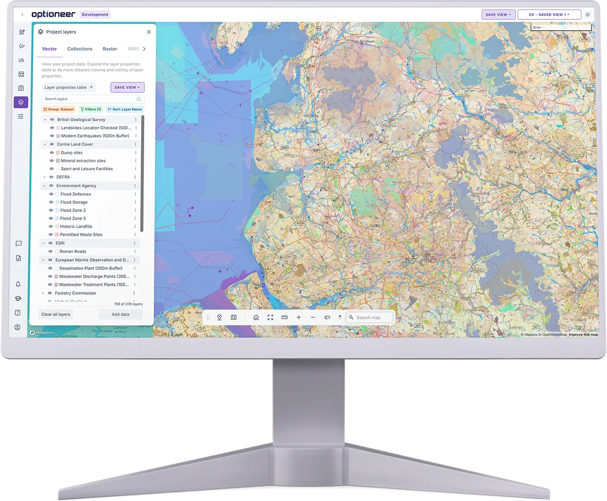
Data layers available in Optioneer for this region


Data layers available in Optioneer for this region

Data layers available in Optioneer for this region
Complied of 13,000+ global, national, regional and proprietary sources
Our data process

Data collection
Sourced from trusted, high-quality, global datasets.
Data formatting
Ensuring data is clean and ready to use in your project.
Categorisation
Selecting datasets that align with your project objectives.
Regular refresh
We constantly carry out quality control and data updates.
Automatic upload
All relevant data is automatically added to your project.
Interoperable
Interoperable with any GIS platform which follows Open Geospatial Consortium (OGC) standards
Multi-format
Our platform works with multiple file formats, including; .shapefile, .geopackage, .geojson, .kmz, .geotiff
Our decision-ready data foundation for infrastructure planning.
Continuum Industries’ data offering goes beyond simply aggregating datasets. Our data specialists structure, categorise, and configure geospatial information specifically for infrastructure routing and siting analysis.
By combining curated datasets, structured planning topics, expert-informed defaults, and permitting insight, Optioneer provides a decision-ready data foundation for infrastructure planning.
Data structuring
Our data specialists clean, standardise, and organise each dataset into structured planning topics, so teams can quickly understand the constraints that matter for infrastructure development.
Legislation, standards and best practice
We link environmental and planning permits to geospatial datasets within Optioneer, helping teams identify early where routing decisions may trigger consenting requirements — supplemented by best practice documentation aligned with discipline requirements or EIAR chapters.
Constraint topics
Datasets are grouped into structured planning topics — including cultural heritage, landscape, environment, hydrology, and utilities — helping users navigate geospatial information and understand how constraints may influence routing and siting decisions.
Default parameters
Optioneer projects are preconfigured with default constraint scoring and technical values developed by Continuum's specialists, reflecting industry guidance and real-world project experience — giving teams a practical starting point for analysis.
Rapid option development
By combining structured datasets with expert-informed defaults, teams can begin generating and evaluating project options immediately rather than spending time configuring models or organising data.
Automated reporting
Optioneer enables users to generate structured reports summarising key constraints, datasets, and decision factors — drawing on both platform data and project-specific inputs to support documentation and stakeholder engagement.
Layer topics
Default data in Optioneer provided by Continuum Industries is automatically categorised, in line with category examples below. These are inspired by the common structure of Environmental Impact Assessment Reports and allows users to get to data insights that are relevant to their work.

We categorise layers into 20 different layer topics:
- 1.
Administrative areas
- 2.
Contaminated lands
- 3.
Cultural & historical sites
- 4.
Economic activity zones
- 5.
Energy resources & industrial areas
- 6.
Geology & soils
- 7.
Hydrology & hydrogeology
- 8.
Infrastructure & utilities
- 9.
Intertidal areas
- 10.
Land rights & planning
- 11.
Land use & land cover
- 12.
Landscape and visual
- 13.
Leisure & recreation areas
- 14.
Marine rights & planning
- 15.
Natural hazards
- 16.
Noise & air quality zones
- 17.
Population density & demographics
- 18.
Sensitive environmental areas
- 19.
Topography
- 20.
Transport networks
Special datasets and partnerships
On top of using thousands of publicly available datasets, there are a few proprietary datasets and special relationships that deserve a specific mention. These are a few examples, and upon request, other data sources can be incorporated, subject to suitable licensing rules.
Land parcels, zoning and ownership (USA)
Through our partnership with Regrid, the leading provider of land parcel data in the US, Optioneer can visualise every land parcel in the US. Parcels are also labelled with zoning, land price, local legislation and ownership information, allowing users to automatically extract land owner information.
Biodiversity baseline (UK)
Following 2023 UK legislation changes, we developed a comprehensive methodology aggregating a number of data sources (Natural England, Ordnance Survey, Open Street Map), allowing visualisation of habitat & biodiversity types across England, Wales, Scotland & Northern Ireland.
OpenInfraMap (Global)
OpenInfraMap aggregates OpenStreetMap data on energy, water, gas, and telecoms infrastructure — providing the most comprehensive starting point for understanding existing infrastructure in an area, despite not being 100% complete.
Custom data uploads (anywhere)
As a customer you can upload your own datasets to Optioneer using multiple file formats, including; .shapefile, .geopackage, .geojson, .kmz, .geotiff. Our platform is interoperable with any GIS platform which follows Open Geospatial Consortium (OGC) standards.
How Optioneer uses data to minimise risk
Optioneer pulls all data to the start of the process. Providing quality data in early development minimising risk and cost in later stages of a project.

Data is not our only tool for project success. Find out how we help you act faster, reduce risk, scale effortlessly, save resources and surpass targets.

Let’s discuss your project
We’ve already helped major network owners like National Grid and SSE move quickly to AI-powered route optioneering. From us, you’ll get a tailored onboarding and partnership plan that moves as fast as you.
Get in touch to find out how we can accelerate your project planning.
Client success stories
We’ve had the pleasure of working with global leaders in the utilities industry, find out how they achieved results with Optioneer.


We will be in touch with you shortly.