Free up your time to focus on the work that really matters.
Our AI-powered software automates repetitive and time consuming tasks in sustainable infrastructure planning and development.
Experts from multiple disciplines collaborate to make better decisions that can be justified with confidence. Outputs are complete, flexible and customisable in line with requirements of the organisation, project or regulations.

Act faster
Accelerate planning and decision-making with automated, reliable option analysis.

Reduce risk
Explore all options in detail at the early stages.

Scale effortlessly
Stay on top of growing requirements and regulatory scrutiny.

Save resources
Automate repetitive, time-consuming tasks to let your team focus on key project challenges.

Surpass targets
Reduce risk, human error and maximise ROI from capital investments.
The world’s leading infrastructure planning platform
high-quality, ready to use datasets.
kilometres of assets designed in Optioneer.
successful projects to date across the globe.
Trusted by 55+ organisations worldwide


Infrastructure networks are becoming larger, more interconnected, and subject to increasing regulatory and environmental constraints. Planning new infrastructure now requires the analysis of vast geographic areas, complex spatial datasets, and multiple competing objectives.
Optioneer was designed to address this challenge.


Title
The platform brings together spatial data, infrastructure modelling, optimisation algorithms, automation and decision making into a single environment for early-stage infrastructure planning.
Rather than analysing individual routes or manually evaluating a small number of scenarios, Optioneer allows teams to systematically explore the full solution space for infrastructure development — identifying feasible corridors, routes, and infrastructure locations across large geographies.
Integrated spatial data catalogue
Infrastructure modelling
Optimisation algorithms
Automation
Data-backed decision making
A wealth of pre-loaded GIS data at your fingertips
Our data library is extensive, in-depth and up to date. Infrastructure planning increasingly relies on integrating large volumes of spatial data across wide geographic areas. Optioneer provides a structured environment where teams can bring together the information needed to evaluate development options with confidence.
Integrated catalogue of 14,000+ infrastructure, environmental, regulatory, and land ownership datasets across the US, UK and EU.

REGRID Land Parcel data in United States, giving full coverage across all of US
National Polygon Service in UK, providing visibility of Crown Land and commercially owned properties
Harmonising national and regional data across EU countries, in line with INSPIRE standards
Ability to combine public, continuously updated, and proprietary datasets within a single project environment.


Data organised into structured thematic layers ready for spatial analysis and optimisation workflows.
Organised into logical groups based on legislation and relevant permits
Linked to baseline costs, level of constraint for development of different assets (overhead / underground)
Integrated datasets
Authoritative data from official sources, packaged and labelled
Includes logical layer groupings and individual feature information
Constraint layers in line with requirements of environmental impact assessment and technical standards

Optioneer generation
Constraints and parameters assessed across millions of options
Options are assessed against cost, risk, visual impacts and following of existing RoWs
Options can be generated by Optioneer or manually drawn
Optimisation happens across multiple objectives simultaneously

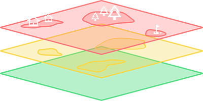
Optioneer evaluation
Detailed summary of hundreds of metrics like overall distance through layer, number of items within x distance, costs, risks
Results are grouped in line with permits, policies, EIA chapters and technical standards
Users can drill down to understand detailed impacts on specific features

Written report generation
Description of the baseline, in line with standard EIA structure
Evaluation of main potential impacts based on Option Evaluation
Assessment of possible mitigation measures
Description of residual impacts based on Optioneer outputs
Overall impact evaluation and description of the risk profile
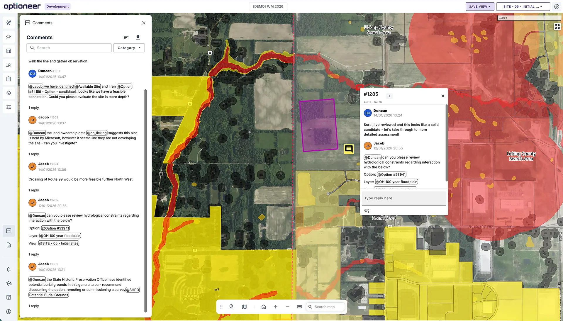
Screen your whole region in real-time, with your team
Get same-day go/no-go decisions on potential infrastructure investments across wide areas. Screening provides early stage discovery of what opportunities are worth pursuing with confidence and due diligence from day one.

Make the right decisions for your network in the long-term.
Analyse entire ISO/RTO areas with the resolution to catch every constraint — proven across PJM, MISO, CAISO, and SPP — while combining global, national, and regional datasets for multi-country projects.
Cloud-based optimisation evaluates large regions supporting hundreds of concurrent users and enabling consultants to work alongside their clients in real time. With optimal infrastructure siting built in and Open Infrastructure Map integrated into every baseline dataset, your team has everything needed to plan, bid, and decide with confidence.
Support for large geographies and multi-country projects, which combine global, national and regional datasets.
Cloud-based optimisation analysing large regions rather than individual projects
Identification of optimal new infrastructure locations, including interventions into existing assets
Capable of handling entire ISO/RTO areas for competitive bidding and system planning
Explore multiple scenarios in minutes
Traditional infrastructure planning forces teams to evaluate options one at a time — slow, resource-heavy, and limiting. Our platform removes that bottleneck, letting you model, iterate, and compare at a speed and scale that matches the ambition of your planning process.

Evaluate millions of configurations
Instantly test bulk sets of interventions - from network upgrades and corridor extensions to entirely new infrastructure builds.
Compare interventions independently
Map hundreds of connection points and existing assets to test and compare system interventions side-by-side.
Iterate faster with reusable assets
Standardise your workflow. Reusable parameters and configurations let you spin up and tweak new scenarios in record time.
Build strategic master plans
Seamlessly combine new linear assets and site locations into cohesive, high-level strategic scenarios.
Collaborate securely
Empower your network planning and development workforce. Flexible, granular access controls make teamwork across clients, consultants, and third parties effortless.
Automate away your most time-consuming processes
Our platform automates the heavy lifting, turning complex, multi-stage processes into streamlined workflows that run in the background while your team focuses on decisions that require human judgement.
Make the right decisions for your network in the long-term.
Our algorithms evaluate Rights-of-Way, asset offsets, and greenfield development concurrently, with detailed technical feasibility assessments applied from the outset — not as sequential geo-processes.
Configurable metrics accommodate bespoke internal governance methodologies alongside established frameworks such as the MISO Transmission Cost Estimation Guide. Weighted ranking, red-amber-green assessment, and Pareto trade-off analysis provide rigorous, auditable comparison across all intervention options.
Automated report generation covers Environmental Impact Assessment screening, crossing and structure schedules, permitting matrices, and receptor-specific risk assessments — reducing weeks of manual drafting to minutes. All outputs are export-ready for direct integration into survey, engineering design, and permitting workflows.
Intelligent route & feasibility analysis
Concurrent evaluation of Rights-of-Way, asset offsets, and greenfield development — with detailed technical feasibility applied from the outset.
Flexible costing & methodology
Configurable metrics support bespoke governance frameworks and industry standards including the MISO Cost Book and PJM Method for Assessment.
Powerful comparison tools
Weighted ranking, RAG assessment, and Pareto trade-off analysis for rigorous, auditable decision-making.
Automated report drafting
Instant generation of EIA screening, crossing schedules, permitting matrices, and receptor-based risk assessments.
Seamless data export
Export-ready outputs for direct integration into survey, engineering design, and permitting workflows.

Robust optioneering in a single project space
Optioneer is designed for collaboration across teams, with each SME getting the information and analysis they need.
Have you got an infrastructure project to deliver?
Reach out today and see how Optioneer can help streamline your project planning and development.
Client success stories
We’ve had the pleasure of working with global leaders in the utilities industry, find out how they achieved results with Optioneer.


We will be in touch with you shortly.