Pipeline routing software
Plan routes for water, wastewater, gas, hydrogen and CO₂ pipelines against real-world constraints — not straight lines and unit rates.
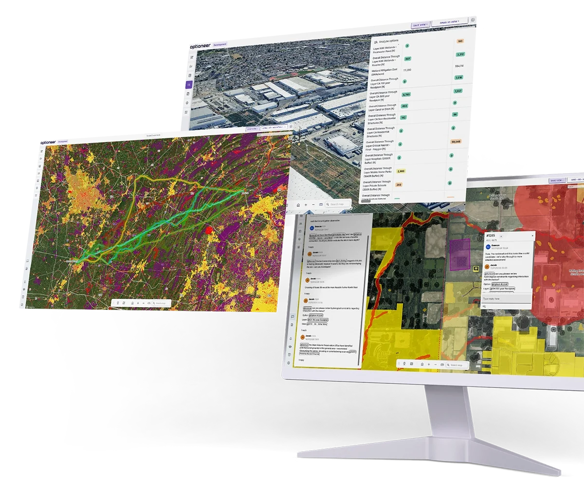
Optioneer is a cloud routing and siting platform for buried pipeline infrastructure. It combines a pre-loaded constraint database, a parametric model of your pipe and construction methods, and multi-objective optimization to generate alignments across whole regions — each one costed on TOTEX, quantified down to crossings and earthworks, and traceable back to the data and weights that produced it.
Used by water companies, gas network operators, hydrogen and CCUS developers and their consultants across the US, UK and EU.
reduction in pipeline routing time, verified in an Energy Networks Association study
of strategic hydrogen corridors assessed across multiple network scenarios, for an entire country of 65m+ people
pipeline route planning at the largest drinking water company in the Netherlands
route confidence in under an hour, rising to 95%+ within weeks
What is pipeline routing software?
Pipeline routing software is a geospatial optimization tool that identifies, evaluates and compares candidate alignments for a buried pipeline between endpoints, or across multiple network nodes.
It converts environmental, land, ground-condition, engineering and cost data into a spatial cost model, then searches that model for alignments that minimize whole-life cost and impact while remaining physically constructible.
It differs from conventional GIS route analysis in four ways:
It generates options rather than scoring a route you have already drawn.
The engineer sets the objectives; the software searches the solution space.
It optimizes across competing objectives at once.
Construction cost, operating cost, environmental impact, land and landowner exposure, customer disruption and safety setbacks are tracked separately, instead of being collapsed into a single weighted score.
It models construction, not just geometry.
Cover depth, bend radius, working width, crossing method, earthworks volume and ground conditions determine which alignments are actually buildable and what they cost.
It produces an audit trail.
Every option carries the constraint set, weights and parameters that created it, so a route selection can be defended at gate review, price review, planning inquiry or permit hearing. The metrics are more detailed than in traditional GIS and include engineering- and permit-driven requirements.
Optioneer does all four — for potable and raw water, wastewater and sewers, natural gas, hydrogen and CO₂.
The data your routing study runs on
Route quality is bounded by data quality. Optioneer ships with an integrated catalog of infrastructure, environmental, regulatory, geological and land ownership datasets covering the US, UK and EU, structured into thematic layers that are ready to weight and run.
For most pipeline studies the overwhelming majority of the required data is already in the platform, which is why teams reach a usable first answer in about an hour rather than after weeks of GIS preparation.
You can upload your own layers alongside the catalog. Optioneer supports standard geospatial formats and interoperates with ArcGIS and Autodesk Construction Cloud.
Sector-specific layers
Source protection zones, aquifer designations and vulnerability, existing water and sewer infrastructure, District Metered Area and pressure zone boundaries, flood zone mapping, contaminated land registers, catchment boundaries. Network condition data — leakage frequency, burst history, criticality — can be layered in to drive renewal prioritization.
Building Proximity Distance zones and population density buffers, existing pipeline corridors and rights-of-way for paralleling or repurposing, Above Ground Installation locations, compressor stations and valve assemblies (subject to the asset owner releasing that data), geological and terrain data for ground conditions and slope.
Constraint layers are grouped against the legislation and permits they relate to, so an environmental planner sees the same alignment through the lens of the consent they have to secure.
Model the pipeline you would actually build
An alignment is only credible if it can be constructed. Optioneer's asset library holds a parametric definition of your pipeline and its construction methods, so the optimizer is bound by the same rules as your design engineers.
Definitions are reusable across projects and teams, which keeps engineering assumptions consistent across a whole capital program.
How Optioneer finds high-quality alignments
Optioneer combines least-cost path analysis with evolutionary, multi-objective optimization.
The two answer different questions, and the combination is what produces alignments that are near-optimal and constructible.
Build the cost model
Every constraint layer is assigned a behavior: hard exclusion, or a cost applied per unit length traversed, per feature crossed, or per unit of proximity. Costs can be monetary — a rate per meter through rock, a lump sum for a railway crossing, a reinstatement rate by surface type — or expressed as risk and impact weights against your own governance methodology. The result is a continuous multi-layer cost model across the whole study area.
For pipelines this step carries more weight than it does for overhead lines, because so much of the cost is in the ground rather than in the pipe. Excavation conditions, reinstatement obligations, utility congestion and crossing counts routinely dominate the CAPEX difference between two alignments of similar length.
Weighting frameworks are saved and reused, so every scheme in a program is assessed on the same basis.
Least-cost path and corridor identification
A graph search across the cost model returns the minimum-cost connection between endpoints, together with cost-distance surfaces showing where viable corridors exist and how much cheaper the best corridor is than its alternatives.
This is fast and mathematically clean, and it is the right tool for screening: working out which of several hundred candidate connection points or transfer configurations deserve further work, and where the strategic corridors lie.
But a least-cost path is not a pipeline alignment. It has no concept of bend radius, cover depth, working width, gradient limits or crossing method, so it will happily return geometry no contractor could build. And it produces exactly one answer per weighting, which tells you nothing about the trade-offs you are accepting.
Evolutionary refinement into buildable alignments
Optioneer therefore treats routing as a search over buildable alignments, not over grid cells.
A candidate is represented by its defining points of intersection — the deflections a real pipeline would use. A population of candidates is generated, seeded from least-cost corridors, existing pipeline corridors and rights-of-way, highway alignments, and any options your team has drawn manually. Each generation, candidates are recombined and mutated: points move, are inserted or removed, sections switch construction method from open-cut to trenchless, crossing points shift to a narrower or more favorable location, and the longitudinal profile is re-derived against the terrain.
Every candidate is then scored by a full evaluation rather than a proxy. That evaluation applies the engineering rules from your asset library, so alignments that breach a bend radius, cannot achieve minimum cover, exceed a constructible gradient, or demand a trenchless drive beyond its length limit are penalized or discarded. What survives is geometry you could take to a contractor.
Over successive generations the population converges on high-performing alignments. Because the search is stochastic and population-based, it explores parts of the solution space a single deterministic path will not reach — including alignments that are longer but materially cheaper to build, or that trade a road crossing for a field crossing and change the whole permitting profile.
Multi-objective search and the trade-off frontier
Objectives are kept separate rather than collapsed into one number. Construction cost, whole-life operating cost, environmental impact, land and landowner exposure, customer or traffic disruption, safety and deliverability are each tracked in their own right.
The optimizer therefore returns a set of diverse options — where no option can improve on one objective without giving ground on another, or to ensure that spatially diverse options are taken forward. That set is the honest answer to a routing question, and it is what your governance process actually needs: not “the route”, but the shape of the choice between a cheaper alignment and a less buildable one.
Pareto visualization, weighted multi-criteria ranking and red-amber-green fatal-flaw screening all run over the same option set, so a strategy lead, an environmental planner and a cost engineer interrogate the same results on their own terms.
Evaluate, compare, iterate
Every option — optimizer-generated or hand-drawn — is scored against the same metric set. Hundreds of metrics are calculated automatically: length through each constraint layer, features within a given distance, crossing schedules by type and method, earthworks volumes, quantity take-offs, affected parcels and landowners, CAPEX and OPEX supporting AACE Class 4 estimates (Class 3 with engineer review), and custom metrics built around your own permits, ODIs or governance framework.
A long-section view shows constraints, crossings and impacts along the alignment, so the profile can be interrogated chainage by chainage rather than only in plan.
Engineers can then move a deflection point, change a crossing method, adjust a parameter and re-run. Iteration takes minutes, which is what makes a genuine desktop study — rather than a sanity check on a preferred line — affordable at the earliest stage.
Optimization executes in the cloud, in parallel, with no local compute requirement. That is what allows a European gas TSO to assess 6,200 miles of strategic corridors across multiple future network scenarios, or a water company to evaluate transfer and reinforcement options across an entire service region, rather than one scheme at a time.
Built around how pipelines are actually routed
Generic corridor tools stop at a line on a map. Pipeline decisions are made on ground conditions, crossings, cover, access and construction method — so that is what Optioneer models.
Terrain profile and earthworks
Pipelines follow the ground, and the ground drives the cost. Optioneer derives the longitudinal profile along every candidate alignment, applies your gradient limits and cover requirements, and estimates earthworks volumes and cost from terrain and geology rather than from an average rate per kilometer. Steep sections, side-long ground, rock and peat are surfaced as cost and risk on every option, not just on the preferred one.
Complex crossings and geotechnical conditions
Crossings of highways, railways, watercourses, canals and third-party utilities are identified per option and scheduled with a proposed construction method. Because ground conditions sit in the cost model, the platform distinguishes a crossing that is routine from one that sits in made ground, over a shallow aquifer, or across a designated watercourse — and prices them differently.
Contaminated land, mining legacy, groundwater and rockhead all enter the assessment at option stage, which is where they are cheap to avoid. Discovered during ground investigation, the same conditions mean redesign, program delay or a mitigation bill.
Open-cut versus trenchless
Construction method is a routing variable, not a downstream detail. Optioneer evaluates open-cut against trenchless techniques — HDD, microtunneling, pipe jacking, auger boring — and, for renewal work, against in-situ rehabilitation methods such as pipe bursting and slip-lining. Method selection responds to obstacle type, ground conditions, environmental sensitivity and drive-length limits, with cost updating automatically.
The practical effect is that undergrounding a sensitive crossing becomes a priced, modeled option rather than a concession made late under consultation pressure.
Minimum cover, separation and safety distance
Cover depth requirements vary by land type and are applied as a constraint on the profile, not checked afterwards. Separation distances from other utilities, structures and foundations are enforced during option generation.
For gas and hydrogen, Building Proximity Distance and IGEM/TD/1 safety setbacks are modeled parametrically against building and population data, so routes are generated compliant rather than corrected into compliance. Changing design pressure or diameter updates the setback — and the routes that satisfy it — automatically.
Hydraulics, pumping and whole-life cost
Elevation profile determines static head; length, diameter and material determine friction losses. Optioneer's topographic and head-loss model turns those into a pumping energy estimate and a whole-life OPEX figure, so a shorter alignment with an unfavorable profile can be compared honestly against a longer gravity-favorable one.
That is the basis of the TOTEX comparison the water sector requires, and it changes conclusions: the cheapest pipe to lay is frequently not the cheapest asset to own. Diameter and pressure class can be optimized against duty and cost in the same exercise, and pumping station, PRV and valve locations sited along the alignment.
Following roads, corridors and existing rights-of-way
Following an existing highway, corridor or easement is often the fastest route to consent and the simplest to access — and sometimes the most expensive way to build, once utility congestion, traffic management and reinstatement are counted. Optioneer evaluates corridor-following and paralleling against greenfield alternatives concurrently, on the same constraint baseline and cost framework, so the comparison is like-for-like. That covers:
- Highway-following alignments, with road classification driving traffic management, reinstatement and utility clash cost
- Paralleling existing pipelines, transmission and rail corridors at a defined offset
- Existing easement and right-of-way assessment — whether the corridor you already hold is wide enough and still viable
- Post-construction encroachment — whether constraints that appeared since the original pipeline was laid now compromise the corridor
Renewal, repurposing and brownfield alignments
Replacing or repurposing an existing asset is a different problem from greenfield routing, and Optioneer treats it as one. Renewals within existing, highly constrained corridors are assessed with the same constraint baseline, scoring methodology and cost framework as new-build alternatives, so the two can be compared directly with auditable evidence behind the choice.
Renewal programs can be prioritized on the difficulty of intervention, not only on where the leaks are. Two mains with the same burst impact can differ enormously in traffic management burden, utility congestion, environmental hurdles and access. Overlaying DMA and pressure zone data surfaces the real risk to customer supply and the complexity of temporary bypasses during construction.
Existing corridors are assessed for hydrogen suitability against material compatibility, capacity requirements and safety setbacks, alongside new-build alternatives on the same baseline. Three British gas utilities have used Optioneer this way to shape their long-term network strategy rather than a single project.
Where pipeline teams use Optioneer
Network strategy and system planning — all pipelines
Project development and consenting — all pipelines
Water and wastewater
Strategic resource options and transfers
Evaluate large-scale transfers, new reservoir connections, desalination links and inter-company transfers from conceptual screening through to delivery. Broaden the option funnel at WRMP stage by rapidly testing alternative connection points, then mature the preferred solution as the scheme moves into business planning. Supports RAPID SRO gate progression, WRMP option development and evidence, and regional planning through WRSE, Water Resources West, Water Resources North and Water Resources East.
Business planning and price review
Realistic, buildable inputs let WRMP and business plan submissions reach price review standard faster, reducing the rework that normally accompanies the transition between planning stages. Aligns with AMP8 delivery, Ofwat's TOTEX efficiency challenge and PR24 outcome delivery incentives, and equips WRMP29 and PR29 with solutions that carry lower cost-certainty risk into delivery.
Mains replacement and rehabilitation
Layer network vulnerability data — leakage frequency, burst history, criticality — against spatial constraints to shift from “where are the leaks” to “how difficult is each intervention”. Build resource profiles and cost estimates from road classification and utility density, and generate the spatial detail needed for Pre-Construction Information automatically.
Storm overflows, CSOs and wastewater
Explore solution pathways at scale — storage, sewer separation, transfer, nature-based options — and stress-test them against cost, installation risk and technical constraints in days rather than months. Supports the Storm Overflows Discharge Reduction Plan, Environment Agency monitoring requirements and Ofwat ODI reporting.
Trunk mains, reinforcement and growth
Route trunk mains and reinforcement schemes for construction, customer continuity and regulatory compliance, with supply interruption risk assessed against DMA and pressure zone data.
AMP8/PR24, Ofwat TOTEX, RAPID SRO gates, WRMP, DWI standards, EA and Water Framework Directive compliance, Storm Overflows Discharge Reduction Plan, Biodiversity Net Gain, DCO evidence for nationally significant water schemes.
Safe Drinking Water Act, Clean Water Act Section 404, EPA CSO control and long-term control plans, AWWA design standards, WIFIA and State Revolving Fund capital programs, NEPA review.
Gas, hydrogen and CO₂
Strategic hydrogen network planning
Evaluate network evolution across a territory — production, transport and end-use connection scenarios, phasing and investment timing — at national or regional scale rather than one route at a time. A European TSO used Optioneer to assess over 6,200 miles of strategic corridors across multiple future network scenarios. Supports the UK Hydrogen Strategy and Hydrogen Transport & Storage Business Model, and aligns with EU Hydrogen Backbone planning.
Gas network repurposing
Assess whether existing natural gas corridors can carry hydrogen, comparing repurposing against new-build on material compatibility, capacity, safety setbacks and spatial constraints — including Building Proximity Distance and IGEM/TD/1 analysis, and assessment of existing Above Ground Installations.
CCUS and CO₂ transport
Route CO₂ from emitters to gathering networks and storage, including connections to injection sites, within cluster development programs.
Pipeline routing and AGI siting
Move from strategic corridor to specific alignment, with compressor station and AGI siting along the route, existing right-of-way assessment for paralleling and widening, and construction access and temporary works planning.
Safety-led routing
Building Proximity Distance and setback requirements applied parametrically during option generation, so safety compliance shapes the route rather than constraining it after the fact.
IGEM/TD/1, HSE requirements, HTBM and hydrogen production business models, CCUS cluster consenting, DCO applications, EIA Regulations, EU Hydrogen Backbone, IPCEI Hy2Infra, REPowerEU.
PHMSA pipeline safety compliance and evidence, NEPA review, Class VI well connection routing, DOE Regional Clean Hydrogen Hubs, and evolving federal siting pathways for hydrogen.
What changes when pipeline routing is automated
Frequently asked questions
How is this different from least-cost path analysis in GIS?
Least-cost path analysis returns one route for one weighting, over grid cells, with no construction constraints applied. Optioneer uses least-cost analysis to find corridors, then searches over buildable alignments — respecting bend radius, cover depth, gradient limits, working width and crossing method — across several objectives at once. The output is a set of options and their trade-offs, not a single line.
Does Optioneer model hydraulics?
It includes a topographic and head-loss model, which is enough to estimate pumping duty and compare options on whole-life cost. It is not a replacement for detailed hydraulic modeling software. The usual workflow is that your hydraulic model defines the connection points and duty, and Optioneer determines whether the pipe serving them can be built, where, and at what TOTEX.
Does it choose between open-cut and trenchless construction?
Yes. Trenchless methods — HDD, microtunneling, pipe jacking, auger boring — are defined as distinct methods with their own costs, ground-condition suitability and drive-length limits. The optimizer selects a method per crossing or section and prices it, and you can force a method where policy or a stakeholder commitment requires it.
How does it handle minimum cover and safety setbacks?
Minimum cover is a parameter that varies by land type and is enforced on the longitudinal profile during option generation. For gas and hydrogen, Building Proximity Distance and IGEM/TD/1 setbacks are modeled parametrically against building and population data, so compliant routes are generated rather than corrected afterwards.
Can it assess repurposing an existing pipeline corridor?
Yes. Existing corridors are assessed on the same constraint baseline, scoring methodology and cost framework as new-build alternatives, so the comparison is direct. For hydrogen this includes material compatibility, capacity and safety setback considerations. In water, the equivalent is renewal within an existing constrained corridor versus a greenfield alternative.
What data do I need to provide to start?
For most US, UK and EU studies, little beyond your endpoints and asset standards. The constraint, terrain, geological, environmental and land ownership baseline is already in the platform. Teams typically add proprietary layers — hydraulic model outputs, asset condition and leakage data, ground investigation, easement records, internal cost books — to sharpen the results.
How accurate are the cost estimates?
CAPEX and OPEX outputs support AACE Class 4 estimates automatically, and Class 3 with engineer review. Estimates build up from the alignment itself — length by land type and ground condition, earthworks, crossings by method, reinstatement, land take — using your cost book or an established framework.
Can the outputs be used in a permit or consent application?
Yes. Customers use Optioneer outputs in DCO applications and environmental submissions in the UK and EU, and in NEPA and state permitting in the US. The platform produces the constraint maps, options appraisal evidence, impact tables and audit trail these processes require. Expert interpretation and authorship remain with your team.
Which pipeline types are supported?
Potable and raw water, wastewater and sewers, natural gas, hydrogen and CO₂. Different asset classes carry different parameters and constraints, and a single project can compare across them.
How long does a pipeline routing study take?
Corridor-level screening across a large region is typically same-day, with around 80% route confidence reachable within an hour of starting. A full options study that would conventionally take months is routinely completed in weeks — customers have reported six months to two, and nine months to three.
Does it integrate with our GIS and investment planning tools?
Optioneer supports standard geospatial formats and interoperates with ArcGIS and Autodesk Construction Cloud. Outputs are commonly used to ground-truth investment optimization models such as Optimatics and Copperleaf, and export into survey planning, engineering design, costing and permitting workflows.
Put your next pipeline through Optioneer
Bring a live scheme, a transfer question, or a route you have already developed — the fastest way to judge the platform is to run it against work you know the answer to.
Client success stories
We’ve had the pleasure of working with global leaders in the utilities industry, find out how they achieved results with Optioneer.
















Learn how Optioneer can accelerate your project development programs

We will be in touch with you shortly.