.png)
.jpg)
Read article
Not every region has a cost estimation guide, but utilities and developers across the US are constantly searching for a detailed, public methodology they can use to build cost estimates that regulators and stakeholders can trust and trace. That's why we've seen the utilities and developers we work with lean on the MISO approach in regions far outside MISO's footprint. Some of the approach carries over exactly as MISO wrote it, with all the same figures. Other parts need some curation to hold up locally, but we've done that curation and built it into Optioneer, so it produces automatic and consistent cost estimates across the US, derived from MISO's trusted methodology.
While MISO's cost guide is naturally written for MISO's own footprint, most of what's in it isn't regional at all. Steel, conductor, hardware, foundations and shield wire cost broadly the same wherever a line is built. So do the adders for clearing forest, matting wetlands and working mountainous ground. The right-of-way widths and conductor choices per voltage class are ordinary engineering assumptions. All of that travels.
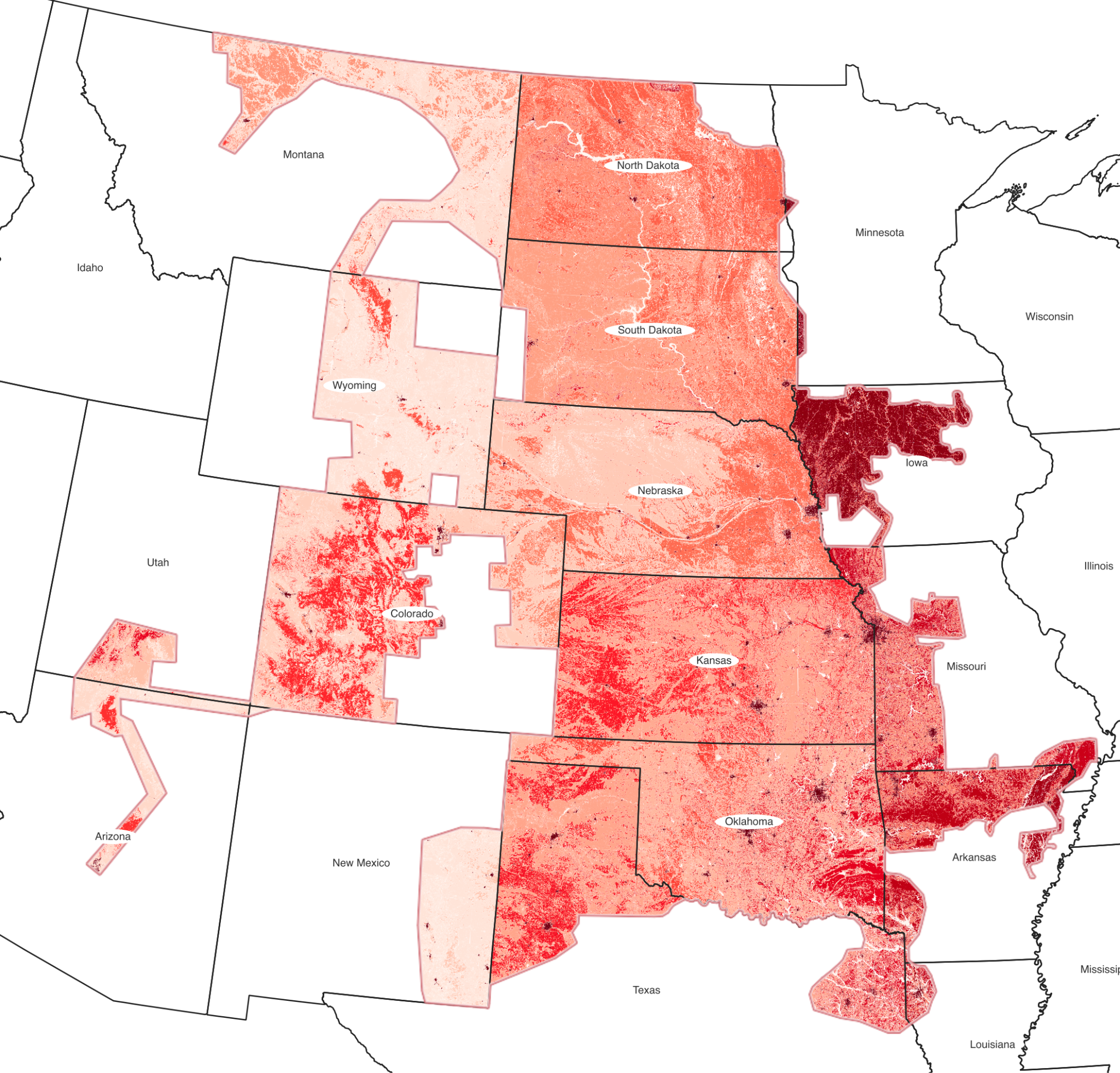
The part that is genuinely local is land. MISO prices land from the USDA's annual Land Values survey: pastureland value by state, with cropland at three times pasture and developed land at five. That survey covers the whole of the contiguous US, not just MISO's footprint. Which means extending the methodology to a new region mostly comes down to pulling the current USDA values for that region's states and applying the same multipliers
We've done exactly that, and it's now implemented in Optioneer, ready to use out of the box across all of the contiguous United States. Every state's land rates were derived straight from the survey using MISO's own method, including the majority of states that have no published MISO figure at all. The result stays consistent with the MISO basis while reflecting what land actually costs locally, wherever the project sits.
The accuracy comes from pairing those per-state rates with state-specific land-use layers in Optioneer. Instead of assuming an average split of cropland, pasture and developed land, Optioneer measures the acreage of right-of-way each route option puts in each land class, in each state it passes through. Land acquisition and permitting costs then reflect the corridor that was actually drawn. And because the rates are per-state, a route that crosses a border is priced correctly on both sides: cropland in one state, rangeland in the next, each at its own local value.
The rest of the estimate assembles the same way as in the MISO case. Each option is routed to the engineering requirements of its voltage, anywhere from 69 kV to 765 kV, with preliminary tower spotting placing structures where they can feasibly go rather than assuming a count per mile. Structure, conductor and shield-wire rates then apply to what was actually spotted and drawn. Access-road and crossing costs (roads, railways, watercourses) can be brought in through further Optioneer functionality, accruing wherever the route meets them. The indirects, contingency and AFUDC go on top exactly as the source methodology specifies.
The upshot is that a planner working in a region without its own published cost guide isn't left guessing at the conceptual and system planning stage. They inherit a credible, current basis, re-sourced for local land values and applied to engineered route options rather than straight-line assumptions. Routing and siting teams get an early read on where a potential project's cost and risk sit, on a method a regulator or stakeholder can recognise and trace.
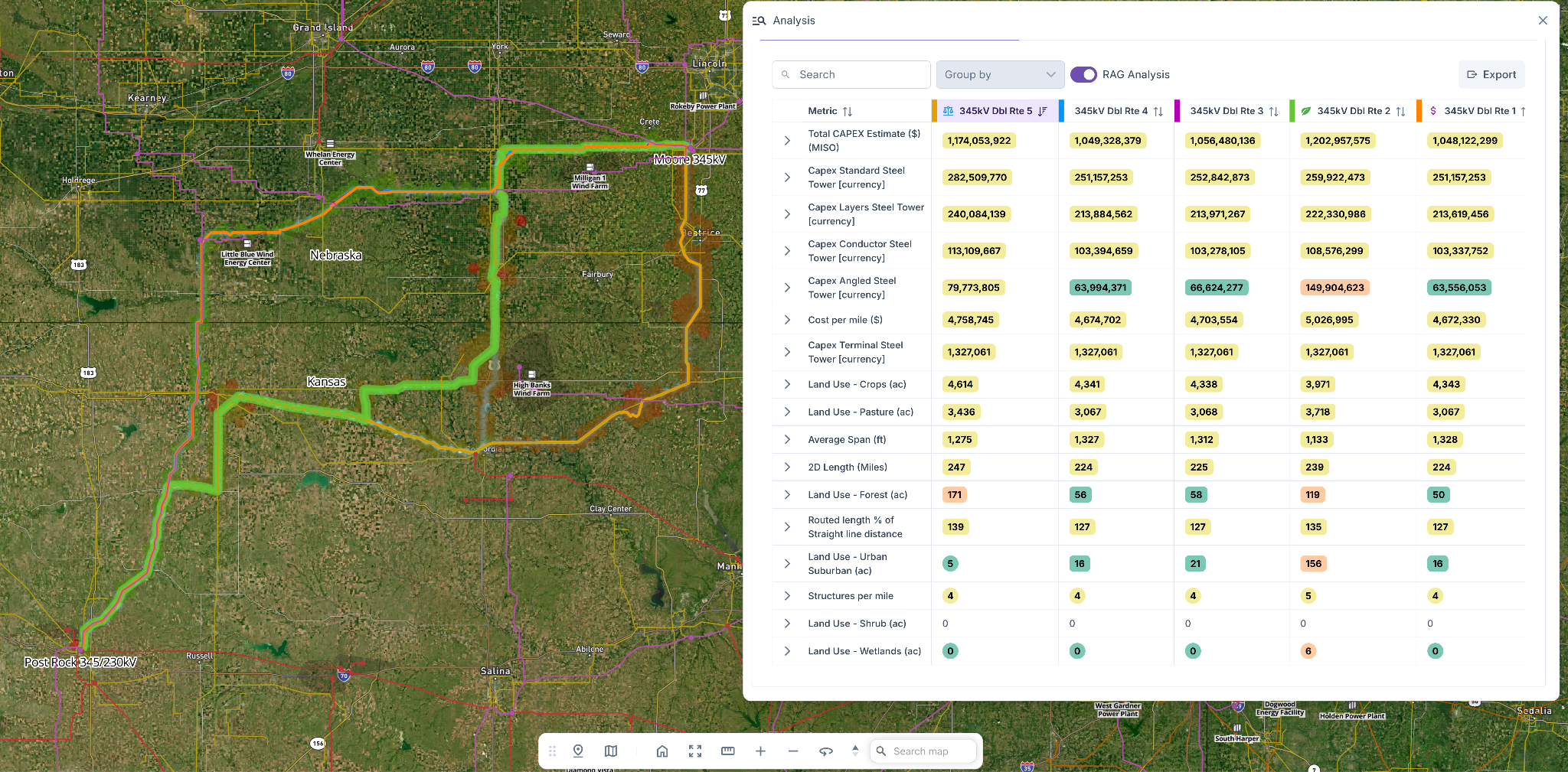
And because the rates are already in the platform for the whole of the contiguous US, there's no setup project to run first. Load the region's land-use layers, pick the voltage, and let Optioneer do the routing.